logo

CLIMATE

Primary menu
  • Home
  • EVSC 1300: Earth's Weather and Climate
    • Course Information EVSC 1300
    • Course Materials EVSC 1300
    • Lecture Links: EVSC 1300
    • Miscellaneous
  • EVSC 3300: Atmosphere and Weather
    • Course Information EVSC 3300
    • Course Materials EVSC 3300
    • Lecture Links EVSC 3300
    • Forecasting Contest
  1. Home
  2. EVSC 1300: Earth's Weather and Climate
  3. Lecture Links: EVSC 1300

Lecture Links: EVSC 1300

National Weather Service

Current Surface Maps (NWS)

NCEP Short-term Forecast

NWS Radar

Plymouth State

Univ. of Wisconsin Weather

Polar Orbiter (MODIS)

Satellites Video

Univ. of Wyoming (upper air)

Earth Visualization

Weather Channel

Weather Underground

NCAR Weather

NCAR 250mb Observations

NCAR 500mb Observations

PSU E-wall

PSU 300mb loop

U.W. 250mb Forecast Loop North Polar View
U.W. 500mb Forecast Loop North Polar View
U.W. 700mb Forecast Loop North Polar View
U.W. 250mb Forecast Loop South Polar View
U.W. 500mb Forecast Loop South Polar View

Principles of Cloud Classification

NWS Upper Air Maps Tutorial

Station Model Symbols Chart

Station Model Practice

Current Surface Station Models

Current Surface Observations

Frontal Analysis

Coriolis Video

Sea Breeze Satellite Imagery (Great Lakes)

Sea Breeze Thunderstorm Development (Florida)

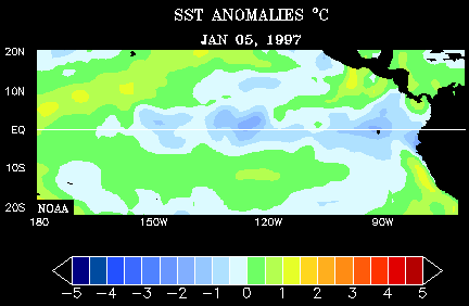
The Relationship Between the Ocean and El Niños

El Niño Animation

CHO Freeze Dates

Heat Lightning

Seven Lightning Types

June 29-30th 2012 Derecho Satellite

June 29-30th 2012 Derecho Radar

Five Kinds of Tornado Video

Hurricanes (2005)

Hurricanes (2010)

GISS Surface Temperature Analysis

Green Flash

Atmospheric Optics

Secondary menu
Powered byOpenScholar®Admin Login
Copyright ©2025 By the Rector and Visitors of the University of Virginia